
Lyme-Old Lyme HS Alum Chris Bugbee Captures Video of Only Known Wild Jaguar in US

Conservation CATalyst and the Center for Biological Diversity released new video today of the only known wild jaguar currently in the United States. Captured on remote sensor cameras in the Santa Rita Mountains just outside Tucson, the dramatic footage provides a glimpse of the secretive life of one of nature’s most majestic and charismatic creatures. This is the first ever publicly released video of the jaguar, and it comes at a critical point in this cat’s conservation.

El Jefe video

The camera project is part of ongoing efforts to monitor mountain ranges in southeastern Arizona for endangered jaguar and ocelot. Chris Bugbee, a graduate of Lyme-Old Lyme High School and now a biologist with Conservation CATalyst, has been collecting data on the Santa Rita jaguar for the past three years (formerly through the University of Arizona).  Bugbee is the son of Old Lyme’s Parks and Recreation Director Don Bugbee and the Rev. Rebecca Crosby, Minister for Haitian Outreach at the First Congregational Church of Old Lyme.

“Studying these elusive cats anywhere is extremely difficult, but following the only known individual in the U.S. is especially challenging,” said Bugbee. “We use our specially trained scat detection dog and spent three years tracking in rugged mountains, collecting data and refining camera sites; these videos represent the peak of our efforts.”

“These glimpses into his behavior offer the keys to unlocking the mysteries of these cryptic cats” said Aletris Neils, executive director of Conservation CATalyst. “We are able to determine he is an adult male jaguar, currently in prime condition. Every new piece of information is important for conserving northern jaguars and we look forward to building upon on these data so that we can collectively make better decisions on how to manage these fascinating and endangered cats.”

“Jaguars have always occurred in Arizona and yet we know so little about them in the northern portion of their range. Arizona should be poised to harbor and protect both jaguars and ocelots as they continue to disperse out from Sonora,” said Bugbee, who now lives in Tucson, Ariz.

Bugbee was featured in an article about the video of the jaguar by William Yardley titled, “He roams alone: El Jefe may be the last wild jaguar in the U.S.” and published in the Los Angeles Times on Wednesday, Feb. 3.

“Just knowing that this amazing cat is right out there, just 25 miles from downtown Tucson, is a big thrill,” said Randy Serraglio, conservation advocate with the Center. “El Jefe has been living more or less in our backyard for more than three years now. It’s our job to make sure that his home is protected and he can get what he needs to survive.”

El Jefe, as he has come to be known in Tucson, has been photographed repeatedly by remote sensor cameras in the Santa Ritas over the past few years. He is the only verified jaguar in the United States since Macho B was euthanized as a result of capture-related injuries in March 2009. “Jaguars are solitary cats that only tolerate each other for reproduction,” said Neils.

But a huge conflict is brewing that threatens to destroy El Jefe’s home. A Canadian mining company is pushing to develop a massive open-pit copper mine right in the middle of the big cat’s territory. The mile-wide open pit and 800-foot-high piles of toxic mine waste would permanently destroy thousands of acres of occupied, federally protected jaguar habitat where this jaguar lives.

“Clearly, the Santa Rita Mountains are a vital part of this cat’s home range,” said Bugbee. “This jaguar has been photographed in every month of the year in these mountains — there are more than 100 detections of him in the Santa Ritas since 2013 — how could anyone argue the importance of these mountains?”

“The Rosemont Mine would destroy El Jefe’s home and severely hamstring recovery of jaguars in the United States,” said Serraglio. “At ground zero for the mine is the intersection of three major wildlife corridors that are essential for jaguars moving back into the U.S. to reclaim lost territory. The Santa Rita Mountains are critically important to jaguar recovery in this country, and they must be protected.”

In October the rare cat was named “El Jefe,” which means “the boss” in Spanish, after a vote by Tucson school kids and others. The Tucson-based Center for Biological Diversity has been working for decades to save jaguars in the United States, with the hope that El Jefe will soon be joined by more jaguars that wander up from Mexico. In 2014 the Center secured more than 750,000 acres of federally protected critical habitat for U.S. jaguar recovery.

Jaguars — the third-largest cats in the world after tigers and lions — once lived throughout the American Southwest, with historical reports on the South Rim of the Grand Canyon, the mountains of Southern California and as far east as Louisiana. Jaguars disappeared from their U.S. range over the past 150 years, primarily due to habitat loss and historic government predator control programs intended to protect the livestock industry. The last verified female jaguar in the country was shot by a hunter in 1963 in Arizona’s Mogollon Rim.

This research builds upon a three-year project (2012- 2015) from the University of Arizona surveying jaguars and ocelots throughout southern Arizona and New Mexico.

Editor’s Notes: i) The Center for Biological Diversity is a national, nonprofit conservation organization with more than 990,000 members and online activists dedicated to the protection of endangered species and wild places.

ii) Conservation CATalyst is a Tucson-based nonprofit organization specializing in conducting scientific research on cats that are in conflict with people.
RiverQuest Now Booking Annual Winter Wonderland/Eagle Boat Cruises on CT River

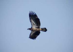
1302_2013FebEagleWatch_024-3a-580x414Connecticut River Expeditions is ready to cruise on the lower Connecticut River this February and March for their 13th Annual Winter Wonderland/Eagle Boat Cruises. These perennially popular winter cruises will depart from Eagle Landing State Park in the Tylerville section of Haddam, Conn.
Cruises will start on Saturday, Feb. 13, and run through March 20.

These cruises are very popular; it is suggested you book early to reserve your spots.

“We are really looking forward to offering this unique cruise during the 2016 winter season. After last year’s horrific ice conditions on the river, we can’t wait to get to work this year,” says Capt. Mark of the quiet, friendly eco-tour vessel RiverQuest.

He  adds, “On this special cruise, our goal is to search for and learn about resident and visiting Bald Eagles and other wildlife we will find on our journey. We feel very fortunate that we are able to bring people out on the river during this quiet season to experience these magnificent raptors and one of our greatest natural resources, the Connecticut River.”

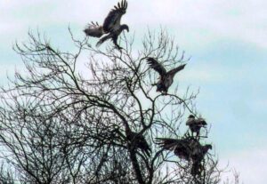
5_immature_eagles_in_a_tree_compressedWithout the summer boat traffic, there is a sense of tranquility on the river and with no leaves on the trees, the river’s edge offers a very different view, making it easier to find and see winter wildlife. In past years, bird sightings have included from one to 41 Bald Eagles, along with numerous hawk and duck varieties, falcons, cormorants and more. On occasion, fox, coyote, deer, bobcat and even seals have been seen.
Winter and early spring are also a great time of year to explore and experience the entire lower Connecticut River Valley. Come out, enjoy and support local businesses. There are shops and restaurants in Haddam, East Haddam and neighboring towns; stop by and visit one before or after your cruise. Although Gillette Castle, just 4.5 miles away from RiverQuest is closed, the park grounds are open for daytime visitors.

Take your camera and binoculars, but if you have no binoculars, there are extras available on RiverQuest for your use during the cruise. There will be complimentary coffee and tea on board.

Weekend and weekday times are available for these 2+ hour cruises. Cost is $40 per person.

It is requested that no children under 10 travel. For more information, departure times and easy on-line reservations visit RiverQuest at ctriverquest.com. 860-662-0577. Private charters and gift certificates are also available.

Old Lyme Conservation Commission Requests Publication of Rogers Lake Long-term Plan

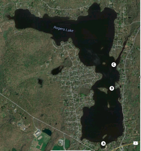
Targeted Areas of Acute Weed Infestation A. Hains Park/Rowing Docks B. Island Narrows C. Boat Launch Area

Targeted Areas of Acute Weed Infestation: A. Hains Park/Rowing Docks, B. Island Narrows, C. Boat Launch Area

The Old Lyme Conservation Commission regards Rogers Lake as one of the town’s most valuable resources  both for its recreational values and for its value as a source for two of the three main aquifers in Old Lyme. This is particularly important at a time when the Rogers Lake Authority plans to apply the herbicide Clipper to large areas of the lake for the very first time.

The Conservation Commission has asked us to publish the 2015 Rogers Lake Long-term Plan:

  1. Reduce the presence of waterfowl around the lake … 40 geese x 3 pounds per day x 365 days = 43,800 pounds of fertilizer per year
  2. Reduce the septic system pump-out frequency to three years and include Lyme lake residents in the program. Consider a local sewer system for Old Lyme’s lake residents.
  3. Encourage the Inland Wetlands Commissions of Lyme and Old Lyme to establish a monitoring system to assure that state law restricting phosphate in lawn fertilizer around water bodies is enforced.
  4. Greatly increase the use of benthic mats, including use of large mats to cover the worst patches of invasive weeds, especially in shallow water motorboat channels (Figure 1).
  5. Establish silt ponds at the mouths of the five largest streams feeding Rogers Lake and maintain them every year by removing the nutrient rich sediment and sell it.
  6. Plan a major fall drawdown (six feet) and plan to deepen boat channels and the worst areas of weed infestation. Establish dewatering areas. Sell the dredged sediment to pay for the operation. Bring in the Connecticut Water Company to provide a local water company to provide water for shallow well owners, permitting major draw-downs and ensuring year round potable water for lake residents.
  7. Establish special zoning regulations for the 500 acre drainage area on the southeast side of the lake to reduce nutrient runoff.  Re-engineer the dam at Ogle Pond so that it can control 3 – 5 inch rain events and prevent flooding of Boston Post Road and Grassy Hill Road.
  8. Assess the area to the north of the lake for nutrients entering the lake during major rain events.  Take steps to reduce this source of nutrients using dams and silt ponds.
  9. Create an email database for all residents of the Rogers Lake basin in order to keep the residents informed and to permit them to play an active role in lake management.
  10. Redevelop Hains Park, including the new boathouse project, community room, pavilion, swimming area and appropriate parking to help integrate and invest the townspeople in the life and affairs of the lake community.
  11. Continue an invasive plant education and monitoring program at the State boat launch to help prevent the introduction of additional invasive species into the lake.
  12. Seal lake bottom sediment in key areas with alum to prevent the release of phosphorus each time the lake becomes anoxic (usually in Autumn).  Even small increases in the levels of phosphorus result in greatly increased weed growth.
  13. Establish a long term plan to dredge the lake. Establish dewatering locations around the lake and establish a specific location nearby to deposit the spoils. Small quantities of material can be annually dredged from the lake without undergoing the extensive and expensive state and federal permitting process.  The Commission suggests that the town take advantage of this opportunity to target specific areas on the lake (See map of Rogers Lake above).

Preserve Closures Announced in Lyme During Deer Firearm Hunting Season

The following Preserves in Lyme will be closed Monday through Friday from Wednesday, Nov. 18 through Tuesday, Dec. 22, 2015 except to licensed hunters with valid consent forms from the Town of Lyme Open Space Coordinator:  Banningwood Preserve, Beebe Preserve, Chestnut Hill Preserve, Eno Preserve, Hand Smith, Honey Hill Preserve, Jewett Preserve, Mount Archer Woods, Pickwick’s Preserve, Plimpton Preserve, and Slawson Preserve.

These preserves, owned by the Town of Lyme or the Lyme Land Conservation Trust, will be open on Saturdays and Sundays during this hunting period as no hunting is allowed on weekends. The hunting program is fully subscribed.

For more information on the hunting program in Lyme, visit http://www.lymelandtrust.org/stewardship/hunting-program/

Last of the (Eightmile River) Dams to be Removed

The Ed Bills Dam locale in winter.

The Ed Bills Dam locale in winter.

The only remaining dam on the East Branch of the Eightmile River will come down as part of a river restoration project led by The Nature Conservancy and American Rivers.

Construction activities will remove the nearly 80-year-old Ed Bills Pond Dam and restore a natural river channel. The restored site will be ready for the return of migratory fish next spring. The project will provide habitat for such native species as brook trout, turtles, and mussels, as well as migratory alewife, blueback herring, Atlantic salmon, American eel and sea lamprey—all also native species.

“Connecticut has more than 5,000 dams. Most of these dams no longer serve their original purposes, yet they unfortunately still prevent fish from reaching spawning habitat critical to their survival. Projects like this one allow us to help change that and restore natural river conditions,” said Amy Singler, who is managing the project for the Conservancy and American Rivers.

The Ed Bills Pond Dam is near the mouth of the East Branch of the Eightmile River on Salem Road.  While the project will be visible from Salem Road, the dam is on private land. For the purpose of safety, public access is restricted. The public will be able to see photos as the project progresses and learn more about it at Facebook.com/CT.NatureConservancy and Facebook.com/AmericanRivers.

The dam is privately owned, and the dam owner is working closely with local and regional project partners to advance river restoration.

Funding partners include The Nature Conservancy, American Rivers, the Connecticut Department of Energy and Environmental Protection, the National Oceanic and Atmospheric Administration, the U.S. Fish and Wildlife Service, the National Fish and Wildlife Foundation’s Long Island Sound Futures Fund, Newman’s Own Foundation, Patagonia, Corporate Wetlands Restoration Partnership, and many generous private donors.

The project will remove the dam and existing fish ladder in order to restore unrestricted natural river conditions through the area flooded by the dam, resulting in access to 9.7 miles of free- flowing river.

Like so many Connecticut Rivers, the East Branch of the Eightmile River has been dammed for more than 100 years; however, the dam being removed was built as recently as the 1940s for aesthetic and recreational purposes. The location of the fish ladder entrance at the dam is not optimal to allow passage of significant numbers of migratory fish.